Discover how Linkages uses the power of geodata to map suitable areas for new developments.
A lack of precision in analyzing the surroundings of a potential investment area for a new venture leads to a series of critical problems that compromise accuracy and increase project risks. A weak analysis results in low predictability, as well as an incorrect interpretation of the true potential of the local market.
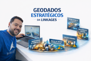
In a scenario of accelerated urban expansion, correctly interpreting the potential of an area is what separates bold decisions from assertive ones. This is where Linkages comes in: we transform complex geodata into strategic clarity so that companies, investors, and public managers can reduce risks, increase predictability, and identify the true potential of each area.
Linkages combines geospatial intelligence, market analysis, AI-powered geospatial modeling, and regulatory diagnostics to deliver a comprehensive view of the territory—from population profile to regulatory environment, from existing infrastructure to local consumption potential. This 360º perspective allows for precise targeting of each Area of Interest's vocation and the identification of opportunities that are not visible to the naked eye.
Below is a practical example of how our data, methods, and geotechnology connect to the surrounding reality of an Area of Interest and drive more strategic direction and decisions.
Socioeconomic scenario and technical potential — The basis of spatial intelligence.
Imagine an Area of Interest in a region with a low average income — R$ 1,104.00 in the census tract and R$ 1,066.00 within a 5km radius — but with clear demographic expansion. The density of 926 households/km² and 259 units in the sector reveals an emerging market, ideal for those who want to position themselves now.
Linkages structures this type of diagnosis by combining:
- Advanced geospatial models of urban density and growth.
- Analysis of population clusters and emerging income.
- -> Intelligence for urban expansion and demand projections.
Technically, this Area of Interest also presents other advantages — gentle slope (1% to 5%), developing access, and proximity to urbanized areas. Our geographical feasibility studies evaluate precisely this intersection between physical environment, accessibility, and logistical potential to define risks, costs, and adjustments to the desired project.
Infrastructure and structural constraints — Where Linkages reduces risk!
The area surrounding the Area of Interest has an extremely favorable service infrastructure:
- -> 60 public schools and 54 private schools
- ->6 markets
- -> More than 40 restaurants
For Linkages, this supply base is essential, as it feeds models of consumption potential, commercial attraction, and population flow.
But just as important as the opportunities are the limitations — and this is where Linkages' technical work in regulatory analysis, mapping legal limitations, and assessing construction risks comes in.
The Area of Interest includes:
- -> Environmental preservation zone with usage restrictions.
- Two transmission lines, with a right-of-way and specific approval requirements.
Linkages automatically cross-references these factors to determine where, what, and how to build, as well as indicating negotiation paths or ways to mitigate restrictions.
Strategic direction — From scattered information to clear strategies.
With structured geodata, business use emerges as the most strategic. The Area of Interest has potential for:
- -> Retail, capturing the growing consumption of social classes C and D.
- -> Leisure and entertainment, attracting flows of upper and middle-class people from other regions of the municipality.
Linkages transforms this information into clear and actionable technical reports, delivering:
- Interactive strategic maps.
- Economic potential simulations.
- Suggestions for the land's intended use.
- Impact analyses and deployment scenarios.
Territorial decisions demand precision. Linkages delivers that precision.
If you want to see beyond the obvious, reduce risks, and identify real opportunities for deployment or expansion, count on Linkages. Discover our complete geospatial intelligence and analysis solutions. Transform data into strategic decisions — with Linkages by your side.